UPDATE: City of Decatur, Atlanta publish list of road closures
Sep 12, 2017
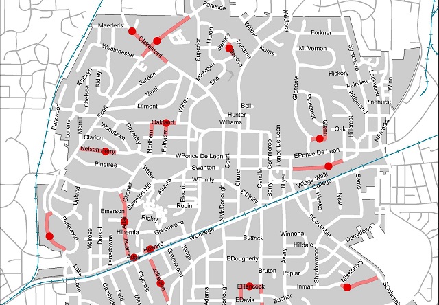
The city of Decatur has published a map of road closures throughout the city as of 4 p.m. on Sept. 12.
The closures are the result of damage caused by Hurricane Irma.
“An updated map will be posted tomorrow, Sept. 13, 2017 by 10:30 a.m.,” the city says. “If main roadways are re-opened before that time, updates will be posted on the City of Decatur Police Facebook page.”
Here’s the map as of 10 a.m. Sept. 13:

The city of Atlanta also provided this list of current road closures …
Zone 1· Lakewood Road NW (at Burton Road)· 86 Morris Brown Drive SW· Collier Drive NW (at Collier Heights Park)· Addison Place NW (at McCally Boulevard)· Linkwood Road NW (at Burton Road)Zone 2· Moores Mill Road NW (West Paces Ferry Road to Northside Drive)· West Paces Ferry Road NW (600 block)· Habersham Road NW (at Valley Road)· Valley Road NW (at Habersham Road)· Peachtree Battle Avenue NW (Eastbound @ Woodward Way)· West Wesley Road NW (at Northside Drive)· East Rock Springs Road NE (at Piedmont Road)Zone 3· Tift Avenue SW (at Shelton Avenue)· Washington Street SW (at Hatcher Avenue)· Old Hapeville Road SW (at Macon Drive)· Bromack Drive SE (at Browns Mill Road)· Octavia Street SE (at Akron Drive)· Bridgewater Street SW (at Lisbon Drive)· 1st Ave· Forrest Park Road SE (at Forrest Drive)· Browns Mill Road SE (Macedonia Rd.)· 3500 Ruby Harper Boulevard SE· Forrest Circle SE (at Forrest Drive)Zone 4· Fairburn Road SW (1500 block and 2600 block)· Avon Avenue SW (at Oakland Drive)Zone 5· Peachtree Street NE (Auburn Ave to Wall Street)· Park Place NE (Auburn Ave to Decatur Street)· Marietta Street NW (Broad Street to Peachtree Street)· Decatur Street SE (Peachtree Street to Pryor Street)· Walton Street NW (Broad Street to Peachtree Street)· Edgewood Avenue SE (Hurt Plaza to Marietta Street)Zone 6· 80 Oakridge Avenue SE· 2698 Memorial Drive SE· Douglas Street SE (at Memorial Drive)· LaFrance Street NE (at Lemon Lane)· Wade Avenue NE (at Wyman Street)· Stokewood Avenue SE (at Pendleton Street)· 1550 Elleby Road SE· 1585 South Ponce De Leon Avenue NE· 835 Lullwater Parkway NE· 442 Clifton Road NE· 1837 Almeta Avenue NE· 349 Elmira Place NE· Winfield Avenue SE (at Bouldercrest Drive)· 227 Wilbur Avenue SE· Confederate Avenue SE (at Lynwood Street)· 683 Confederate Avenue SE· 551 Cherokee Avenue SE· 700 Oakland Avenue SE· 526 Hill Street SE· 323 Milledge Avenue SE· Bass Street SE (at Grant Street)· Jackson Street NE (at Boulevard)· 1045 Blueridge Avenue NE· 1170 Woodland Avenue SE· Woodland Avenue SE (at Bern Street)· 960 Delaware Avenue SE· 1029 Woodland Avenue SE· 1100 block of Woodland Avenue SE· 1606 Wellswood Drive SE· 680 Woodland Avenue SE
[adsanity id=37799 align=aligncenter /]
[adsanity id=37962 align=aligncenter /]
[adsanity id=33719 align=aligncenter /]